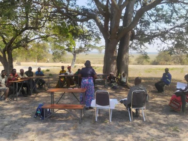
Validation of the PSAT in the village territory of Ekombe. In the presence of the Provincial Minister of Land-Use Planning, the Head of the PIREDD Équateur Project, the Chief of the Elanga Sector, and the local community. Photo credit: Arielle Nkodo (FAOCD).
In the heart of the Congo Basin, Équateur province in the northwest of the Democratic Republic of the Congo is home to exceptionally rich forests. Not only are these ecosystems the lungs of the planet, they are also the foundation of daily life for local communities. However, this precious region is now facing multiple threats, such as increasing deforestation, persistent poverty, demographic pressure, the absence of land-use planning, and limited land governance. Responding to these challenges, an innovative and ambitious initiative is underway - participatory land-use planning, led by the Integrated Program for Reducing Emissions from Deforestation and Forest Degradation (PIREDD-Équateur). Funded by the Central African Forest Initiative (CAFI) and the Swedish government through the National REDD+ Fund (FONAREDD), this program is jointly implemented by the Food and Agriculture Organization of the United Nations (FAO) and the World Wide Fund for Nature (WWF).
A coordinated and inclusive approach to land-use planning
As part of this initiative, out in the field, FAO works closely with the relevant provincial administrative services - such as the Provincial Office of the Environment and the Provincial Division of Land-Use Planning, to support local communities in the development of Simple Land-Use Plans (Plans Simples d’Aménagement du Territoire, or PSAT). This process is based on a participatory approach in which communities themselves designate areas for agriculture, forestry, residential use, or conservation. The dialogue between local knowledge and modern technical support forms the foundation of this initiative.
The development of a PSAT follows several key steps:
- Socio-economic survey - aimed at understanding local dynamics, land use practices, and household needs.
- Cartographic representation of territorial boundaries and available resources, based on community knowledge.
- Data collection on boundaries and natural resources, including forests, water bodies, agricultural lands and habitats, etc.
- Map-based allocation of management units according to the functions defined by the communities (agricultural zones, conservation areas, development zones, etc).
- Collective definition of usage rules and monitoring measures, often inspired by customary practices but reinforced with a focus on sustainability.
- Georeferencing and digitization of the participatory maps to ensure readability, proper archiving, and compatibility with official planning tools.
- Validation of the PSAT by the communities in the presence of local political and administrative authorities, which strengthens the legitimacy of the document.
This structured process not only promotes better land-use planning but also enhances local capacity in land governance. By empowering communities in land management, PIREDD-Équateur contributes to reducing pressure on forests, securing land rights, and strengthening resilience to climate and economic crises.
Free, Prior and Informed Consent at heart of the process
Before any intervention takes place, a Free, Prior, and Informed Consent (FPIC) process is required. This protocol ensures that communities understand the objectives of the project and agree to participate voluntarily, with full respect for their rights. Each participating territory signs an FPIC document written in both French and the local language (often Lingala) to guarantee full understanding of the process.
FPIC sessions involve broad community representation: traditional chiefs, village leaders, elders, respected figures, Indigenous Pygmy Peoples, women, and members of Local Development Committees (CLDs). This inclusive framework ensures that local aspirations are voiced and considered, anchoring the project firmly in the realities of the territory.
Out of the 70 preselected village territories, only two declined to participate. They were replaced by two other territories whose communities expressed willingness to engage in the process, thus demonstrating strong overall support for participatory land-use planning.
Community maps lean on traditional knowledge, memories of local communities
With technical support from provincial agents, communities themselves produced land-use maps of their territories, drawing on deep, generational knowledge of their environment (Figure 1). These maps reflect not only a rational spatial organization, including agriculture, hunting, fishing, conservation and reforestation, but also a living collective memory tied to the land, rivers, and sacred sites.
These maps are not merely technical documents, they are acts of identity recognition, tools for mediation, and levers for sustainable and equitable resource management. They serve to:
- Clarify land rights and usage.
- Prevent conflicts between users.
- Curb the uncontrolled expansion of agricultural activities.
- Optimize resource management through the enhancement of agroecological knowledge.
- Highlight sensitive areas such as sacred forests, water sources, or high-biodiversity zones.
They also lay the groundwork for fair collaboration with conservation, investment, and rural development projects.

Figure 1. Participatory mapping of boundaries and future land use in the Penzele II territory, Elanga sector, Bikoro territory, Équateur Province, the Democratic Republic of the Congo. Photo credit: Rager Ngange (Provincial Environmental Coordination – Équateur Province).
A balanced territorial vision: Data and land allocation
The 70 validated PSATs cover a total of 314,687 hectares of community land. The distribution of these areas reflects a clear commitment to the protection of natural resources. Table 1 below presents the different land-use categories within the 70 territories that were supported in the development of their PSATs.
Tableau 1. Land use allocation across the 70 PSATs
|
Land Use Category |
Area (ha) |
Relative Share (%) |
|
Conservation zone |
221,224.29 |
70.30 |
|
Rural development zone |
37,554.32 |
11.93 |
|
Protection zone |
31,099.50 |
9.88 |
|
Timber production zone |
17,184.27 |
5.46 |
|
Residential zone |
3,624.22 |
1.15 |
|
Community forest concession |
3,819.85 |
1.21 |
|
Protected savanna area |
181.36 |
0.06 |
|
Total |
314,687.81 |
100 |
This configuration illustrates the communities’ strong commitment to preserving forests and fragile ecosystems, with over 80 percent of the land designated for conservation and protection zones. The remaining areas, allocated to rural development and wood production, reflect a balanced consideration of local economic needs. The georeferenced maps, along with the validated PSATs, are handed over to the communities to serve as a guide for any future investments within the territory, thereby ensuring sustainable and coordinated resource management.
The map below (Figure 2) shows the spatial distribution of the 70 PSATs developed in the Bikoro territory, within Équateur province. It highlights the scale and geographic coverage of the participatory planning process implemented in the region.

Figure 2. Location of the 70 Simple Land-Use Plans developed in Bikoro Territory, Équateur Province, the Democratic Republic of the Congo.
Community land rights gradually recognized
The PSATs, combined with Local Community Forest Concessions (Concessions Forestières des Communautés Locales, CFCL), constitute powerful tools for land governance. Through their development, communities demonstrate their capacity to sustainably manage their lands: local rules are established -such as prohibitions on fishing with mosquito nets, cutting trees in conservation zones or sacred forests, hunting wildlife species protected by customary law and expanding fields into areas designated as protected forest. These rules originate from customary traditions but are formalized within the PSATs.
Figure 3 illustrates this formalization process during the PSAT validation ceremony in the village territory of Ekombe (Elanga sector), held in the presence of the Provincial Minister of Land-Use Planning, the head of the PIREDD-Équateur project, the chief of the Elanga sector, and the local community.
These norms reflect effective local governance that combines indigenous knowledge with global sustainability goals. They embody the commitment to preserve natural resources for future generations and to structure local development through consultation and consensus.
A more favourable legal framework
The recent enactment of Law No. 25/045 on July 1, 2025 in the Democratic Republic of the Congo, concerning land-use planning, marks a historic breakthrough. It establishes a legal framework conducive to integrating PSATs into public policies at the national, provincial, and local levels. Thanks to their social legitimacy and community grounding, PSATs have become relevant instruments to:
- Plan the deployment of public services (rural roads, schools, markets, health centers).
- Secure agricultural lands and sensitive zones.
- Promote sustainable investments in local territories.
At the same time, 28 CFCL titles covering 281,225 hectares have been granted with the support of PIREDD-Équateur, enabling communities to manage their forests according to their own sustainable development priorities.
In summary, the implementation of PSATs constitutes an integrated response to the challenges of deforestation, land tenure insecurity, and rural development in the Democratic Republic of the Congo. It is based on an inclusive approach, founded on the active participation of communities and the legal recognition of their rights.
With support from FAO and WWF, PIREDD-Équateur demonstrates that participatory territorial planning is not only a management tool but also a catalyst for change towards more equitable, resilient, and sustainable land governance.